
|
| Our subscribers' grade-level estimate for this page: 6th |
| Answers | Label Central America |
Geography Printouts |
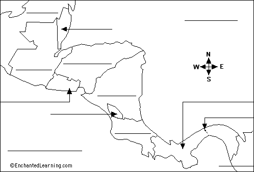
Belize - a country in Central America at the southeast border of Mexico and northeast of Guatemala. Costa Rica - a country just north of Panama. El Salvador - a country in Central America that is south of Guatemala and Honduras. Guatemala - a country in Central America south of Mexico and west of Belize. Honduras - a country northeast of Nicaragua. Nicaragua - a country just north of Costa Rica. Panama - a country at the southernmost tip of Central America. |
Atlantic Ocean - the ocean east of Central America. Colombia - a country in northwestern South America; it is southeast of Panama. Lake Nicaragua - a large lake in Nicaragua. Mexico - a country southwest of the USA and north of Guatemala and Belize. Pacific Ocean - the ocean west of Central America. Panama Canal - a man-made canal in Panama that connects the Atlantic and Pacific Oceans. |
| Search the Enchanted Learning website for: |